The scenery in and around Granby is absolutely stunning and worth exploring. It is near impossible to cover all of this area by foot, but you can explore some incredible places by car. You won’t want to pass up the chance to experience these breathtaking routes and all of the Rocky Mountain activities these roads have to offer. So get out your itinerary – here are some beautiful scenic drives that shouldn’t be missed when you visit Granby.
Colorado River Headwaters Scenic Byway
Length: 80 miles
Driving Time: 1.5 hours one-way
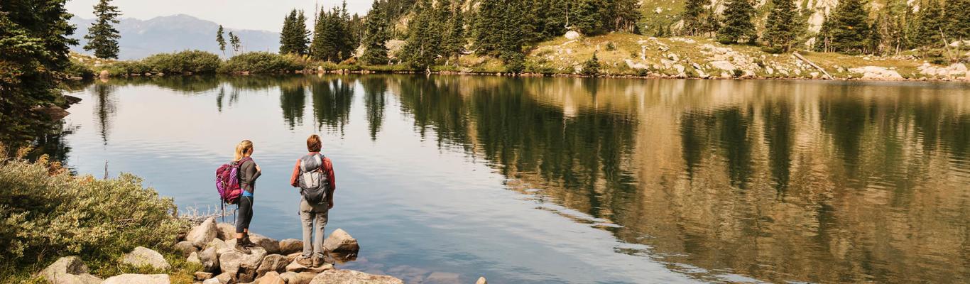
Starting at the mouth of the Colorado River in Rocky Mountain National Park, this scenic byway is one not to miss if you’re traveling through Granby. The Colorado River Headwaters Scenic Byway is around 80 miles in its entirety, passing through the towns of Grand Lake, Granby, Hot Sulphur Springs, and Kremmling. The road follows the bends of the Colorado River, eventually bringing you through Gore Canyon and all the way to the town of State Bridge.
There are so many wonderful outdoor activities and Rocky Mountain adventures to be had on this route. You can explore three beautiful lakes: Lake Granby, Shadow Mountain Reservoir, and Grand Lake. The water may be cold, but in the summer months, it is definitely worth taking a dip. You can also rent a boat and enjoy being out on the water in the middle of these incredible high-alpine lakes. Discover whitewater rafting in Kremmling or bring out your waders for some fly fishing on the Colorado River. Maybe even take a hike on one of the many trails you will encounter along the way. In Hot Sulphur Springs, there are even hot spring pools available for soaking if you choose to do so. The views and recreational activities are endless while traveling the Colorado River Headwaters Scenic Byway.
Ute Pass (County Road 3)
Length: 27 miles
Driving time: 40 minutes one-way
Ute Pass is a popular scenic route for locals that is used to travel between the towns of Parshall and Silverthorne. This road and all of its beauty has so much to offer for anyone who chooses to travel along its path.
Driving this scenic road provides the opportunity to explore both the Arapaho and Roosevelt National Forests. Hiking is easily accessible in many areas, and you should definitely check out the Ute Pass Hiking Trail as well as Ute Peak. Fly fishing and spin fishing are also available, as you will have access to the Colorado and the Blue River. You will pass by Williams Fork Reservoir and a short detour away is Green Mountain Reservoir in Heeney. Be sure to take a peak at Henderson Mill to experience some of Colorado’s rich mining history. Ute Pass is not far from the town of Granby, and is accessible off of US Highway 40 in Parshall.
Cottonwood Pass (County Road 55)
Length: 10 miles
Driving time: 20 minutes one-way
Cottonwood Pass is a great scenic route that takes you through some of the mountains in Granby. It begins off of US Hwy 40 about 4 miles southeast of town, eventually looping you west around to the town of Hot Sulphur Springs. This road is best traveled from May through October as snow makes it unpassable during the late fall and winter months. This route is a bit “off the beaten path” and allows you to view free range livestock grazing in the surrounding fields as well as beautiful natural streams and seclusion. This is a public road, but it passes through a few private ranching properties. Be sure to have a plan of action if you would like to hike or camp in this area.
Corona-Rollins Pass
Length: 15 miles
Driving time: 45 minutes one-way
Corona-Rollins Pass is a beautiful, unpaved 4×4 road that can be accessed by a high-clearance four-wheel drive vehicle during late spring and summer, or by snowmobile during the fall and winter months. This road climbs up the Continental Divide from Winter Park and is located off of US Highway 40. This is an abandoned railroad route and offers incredible views of the eastern and western slopes of the Continental Divide, topping out at 11,676 feet. This drive offers access to incredible hiking trails and the opportunity to fish in high-alpine lakes. Note that this road is not maintained, so walking up the road is an option if your car can't make it.
Trail Ridge Road
Length: 48 miles
Driving time: 2 hours one-way
Beginning in the town of Grand Lake while traveling through Rocky Mountain National Park, Trail Ridge Road is a “bucket list must-do” for many. It is 48 miles long and the highest paved continuous road in the United States. From Grand Lake, this scenic route traverses over the top of the Rocky Mountains and winds you down into the picturesque mountain town of Estes Park. At its highest elevation, Trail Ridge Road reaches 12,183 feet. The road is entirely paved, but depending on the weather, is only able to be fully accessed during the months of May or June through October. The National Park Service shuts down this scenic byway due to snow for around seven months each year.
The possibilities of hiking, sightseeing, experiencing locally guided tours, and creating unbelievable memories are endless in Rocky Mountain National Park. Be sure to stop at one of the many scenic overpasses off of Trail Ridge Road to enjoy the beautiful surroundings. This scenic byway is perfect if you want the opportunity to view wildlife or experience some incredible classic Colorado views.